www.FranzosenbuschHeritageProject.org
Home
Western Springs -- 19th and Early 20th Century
Why did the area attract so many settlers in the 1830s?
The five million acres surrounding Chicago belonged to the
Pottawatomie. The transportation "craze" of the time was for canals
linking major waterways. The idea of the Illinois and Michigan Canal,
linking Lake Michigan to the Illinois River (and down the Mississippi to New
Orleans), became very popular. Unfortunately for the Native Americans the
canal would cut through lands ceded to them.
In 1833, under pressure from local and federal governments,
the Pottawatomie exchanged their holdings for land in Iowa and one millions
dollars in goods. Much of the 'goods' went to creditors -- a scandalously
bad deal for the Native Americans deplored in many contemporary accounts.
By 1835, the vast majority of the Native Americans had moved from the Chicago
area and new settlers arrived. For the settlers this opened up a great
deal of public land for their farms and homes.
Another feature which attracted settlers to the immediate area was Salt
Creek. This creek had a:
- source for clean water
- a location for hunting and trapping animals
- a navigable river
especially during the spring
The area had been popular for years by the Pottawatomie and other Native
Americans (See
Native American Settlements of 1804).
The early settlers and trappers of European descent also liked the benefits of
Salt Creek.
For more background information see:
In 1828 to the east within Lyons Township, David and Barney Laughton,
two brothers from Bourbon Springs, built a house near the present day Burlington
Railroad in Riverside. A year later Stephen Forbes (later
the Cook Country Sheriff) settled in the township.
In 1832 to the north in Proviso Township, Aaron Parsell operated the first saw mill located on the
east side of the Des Plaines River where the Chicago Northwestern railway now
crosses it.
In 1833 another saw mill began operation in near the Parsell's. It was
owned and operated by George Bickerdike and Mark Noble.
In October of 1833, Thomas Reed Covell bought a large tract of land covering many
sections of the area from the government. The northern boundary line of
Covell's property reached the location of Madison Street, the Eastern line,
Mannheim Road, and the southern boundary about a mile north of LaGrange. Covell's log cabin was on the west side of Salt Creek just north of
LaGrange in what would become Section 28, Proviso Township.
1834 found the new Chicago-Dixon Road was the primary artery.
Early Area Land Sales
The earliest known land sales in the Western Springs area were recorded in
1835.
On the 24th and 25th of June ten men each bought between 40 and 160 acres at
prices of $1.20 to $1.30 per acre.
- Walter L. Newberry was one of those men, buying 146 acres in the
northwestern portion of the village. (He would later found the
Newberry Library in Chicago.) Members of the Fuller family would farm
portions of his land.
- Joseph Vial purchased 80 acres in the area of the current Ridgewood
subdivision.
The
Joseph Vial family had arrived in our area from New
York State in 1834. The Pottawatomie were still in the
area. In the book La Grange Centennial History 1879-1979 he is
quoted as saying, "That Indians were never troublesome after we came. I
remember old Shabbona, head chief of the Pottawatomie. He was about the
noblest specimen I ever saw. It was through his (Shabbona's) efforts that his tribe
remained quiet during the Black Hawk War (1832)."
The Vial’s first log cabin served as an inn, post office,
store, and was the meeting place for Cook County’s first Democratic Convention
in 1836.
In 1856, Robert Vial, Joseph’s son, built a two-story frame
farmhouse on Plainfield Road. This structure is the structure which was
saved by the Flagg Creek Historical Society when it was threatened by demolition
in 1989. After several years of restoration, the home opened to the public
in 1999 on a regular basis.
Members of the Vial family would later own Vial’s Lumber
Company before selling it to Lord’s Lumber Company.
In 1836 Sherman King bought 80 acres in the Western Springs area.
He also built a sawmill along Salt Creek which would become the Graue sawmill
-- not to be confused with the Graue grist mill which came later.
The earliest settler known to have lived near the present
boundaries of Western Springs was Elijah Wentworth, Jr. Moving to the
area in 1838, he built a tavern, called "Black Horn", just south of the
present village limits. Although Elijah Wentworth left the area about
1850, and had little impact on the developing community, his family left a
lasting mark on the city of Chicago, where Elijah went on to become the first
coroner of Cook County. His son, known throughout the Midwest as "Long John"
Wentworth, became the first mayor of Chicago. He also sold the land
where White Sox Park (the previous one) was situated to Charles A.
Comiskey.
1840s and 1850s -- Slow Growth and the "Plank" Road
The area's residents were mostly farmers. People were reluctant to move
to the area -- so distance from Chicago with transportation as a major problem.
The stage coaches between Chicago and the western settlements passed through
every two or three days along the stage line on Chicago and Dixon Road (now
Odgen Avenue). Leitch continued his development efforts. In the
early 1860's Leitch chose the name Kensington Heights for his development
project, but soon after he suffered some business reverses and was forced to
abort the project.
But settlers did come to the area:
- 1845 Charles G. Puscheck settled in the north of
Roosevelt Road and east of Mannheim.
- Henry Evers came from Germany in 1850 and settled on a farm
one block south of Roosevelt on Wolf Road.
- Henry Bohlander, the father of George, ran a harness
shop in Brush Hill. George was also a harness maker and a talented violinist.
Irving Porter, in the northwestern area (now Hillside), started a horse
trading business on his farm during the Civil War.
- In the 1850s Fred Graue and his family were elated
when they welcomed the Franzosenbusch German settlers who purchased forty
acres for a school and a church on the corner of 22nd
Street and Wolf Road. These were his friends and townspeople from Hanover,
Germany, and they were his new neighbors.. Ferdinand Klaas, the
blacksmith, was also a postmaster. His blacksmith shop stood on the opposite
corner from Thiele's trading post and general store on 22nd Street
and Wolf Road (the former the site of Lilac Lodge – now just north of the
Walgreens).
In 1848 Nicholas Torode's saw mill was located on
Salt Creek (near Fullersburg -- the general area surrounding the current
intersection of Odgen Avenue and York Road). That year Torode's saw mill
burned to the ground. Not long after, Fred Graue and his partner William
Asche, stood among the ashes of their saw mill located near Torode's in Brush
Hill, now Hinsdale. Fred Graue vowed then to rebuild on the same spot,
not a saw mill, but a grist mill constructed of brick and stone. He bought out
his partner and labored for five years. Finally, in 1852, golden cornmeal,
whole wheat, white or rye flour and feed for farm animals were available to
the entire region. Native Americans wandered to Fred Graue's mill during maple
syrup time knowing they would receive corn cakes covered with the sweet syrup.
Fred Graue's mill became one of the few authenticated Underground Railway
stations in Illinois. It was managed by John S. Coe and Miller Graue who hid
the runaway slaves in the mill's cellar. The old Southwest Highway, now Ogden
Avenue, became the established route between Chicago, the mill and the boats
to freedom. Abraham Lincoln, while in office as the State Legislator, stopped
at Graue's mill for a visit while passing through to Chicago.
The construction for the 'plank' road was started by as a private
venture. A wooden 'plank' road was built along the old Chicago-Dixon route.
Its roadbed
consisted of eight-foot-planks nailed to stringers on either side of the road.
By 1850 the section from Chicago to Brush Hill in Hinsdale was completed.
By 1851 the planked sections extended to Naperville and it was renamed the
"Southwest Plank Road". The total construction cost of $16,000 was recouped by charging a toll
to use the road.
1864 -- Railroad Comes To Town
In 1864 the 38-mile Aurora-Chicago railroad line was completed
at a cost of one million dollars. The rail line changed its name
to a more appropriate "Chicago, Burlington, and Quincy Railroad. It was
this railroad which first assigned the name "Western Springs"
after the nearby
mineral springs. As with many other villages along a rail line, the railroad brought many
persons to settle in the area as it carried the farmers' produce and milk.
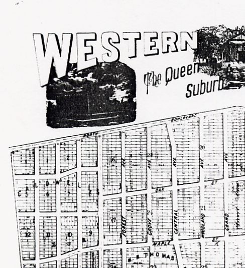
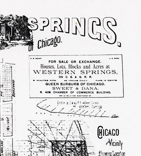
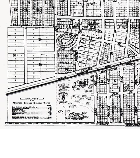
What were the Western Springs?
There WAS a natural spring -- Alcyone Springs. Its
water were told to have great healing powers. They had been used for a
long time by local Native Americans. It flowed at a rate of 40 gallon per
minute. Visitors used to travel from Chicago
and other places to drink the spring water. At one time the water was
bottled and shipped by the "Alcyone Mineral Spring Company" via the Aurora-Chicago railroad line for consumption
elsewhere. For more about the fate of this natural spring, see
The Springs of Western Springs.
1870s -- Development and Growth Spurt
In 1870 much of the land within the present boundaries of Western Springs had
been purchased by a syndicate of wealthy Chicago men:
- the sons of Phillip F. W. Peck, a Chicago merchant
- William R Page, a Chicago attorney
- Thomas C. Hill, salesman and promoter, Quaker
These men purchased the tracts of land (using the name Western Springs Land
Association) from:
- Ben Fuller, founder of Fullersburg (York Road and Odgen Avenue)
- David Roth
- Henry Runge
 "Sensing that the railroad line from Chicago which ran through the area would
make the location a viable suburban community, the landowners planned to
subdivide and develop the property. The total price of the three tracts of
land was approximately $105,000. Early records indicate that each of the
four syndicate members contributed equally toward the purchase. The Pecks,
however, worked in the background. Hill took a much more active role and
acquired the title of general agent of the association....
"Sensing that the railroad line from Chicago which ran through the area would
make the location a viable suburban community, the landowners planned to
subdivide and develop the property. The total price of the three tracts of
land was approximately $105,000. Early records indicate that each of the
four syndicate members contributed equally toward the purchase. The Pecks,
however, worked in the background. Hill took a much more active role and
acquired the title of general agent of the association....
"The Peck-Page-Hill syndicate sold 24 lots before most of the city of Chicago
was destroyed by the Great Fire of 1871. No additional lots were sold for
the remainder of the year, and only 12 the following year."
The above text is from the book, "Western Springs, A Centennial History of the
Village", by the Western Springs Historical Society
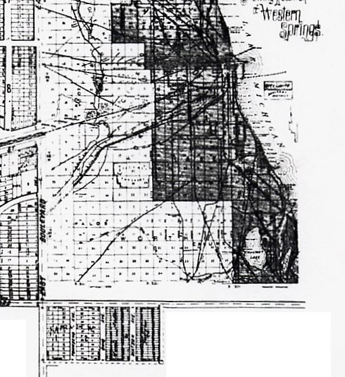
The map to the right reflects the approximate street layout in
1876. East Boulevard is now Wolf Road. North Boulevard is Odgen
Avenue. South Boulevard is 47th Street
Thomas C. Hill took up residence at 4344 Grand Avenue as he tried
to lure Chicagoans away from the urban area, an act made easier by the
devastation of the Great Fire. He called this area "East Hinsdale".
Besides attracting more Quakers, Hill's advertising campaigns attract many
Swedes and other settlers from Central Europe to the area.
1875 saw the "East Hinsdale" development partitioned, subdivided and given
the name "Western Springs Subdivision". The northern boundary was Odgen
Avenue, the eastern boundary Wolf Road (then East Boulevard), the southern
boundary South Boulevard (47
th
Street). The western boundary was much the same as the current village
boundary. (See 1920s map below.)
To the east LaGrange incorporated in June of 1879.
1880s
By 1884 the village had grown to 290 residents. The Quakers built the
Friend's Church which could also be used as a village hall. The new Grand
Avenue School replaced the wooden school house. It too was used for early
village meetings.
On December 12, 1885, area residents assembled in the railroad depot to
consider the village incorporation. They voted 34 to 25 the referendum
passed. The Village of Western Springs was incorporated in 1886 and
elections were held for a president, clerk, police magistrate and six trustees.
The first official village meeting was held on February 12, 1886, after the
January 30 elections. The new trustees elected were:
- William B. Wickersham
- Julius O. Jaehne
- E. E. Barrett
- Thomas C. Hill
- Joseph Marshall
Thomas C. Hill was elected the first village president. Hill appointed
Fred Titsworth as village clerk. Hill served until April when new
elections were held.
John Atwater became the new village president in April, serving through 1887.
In 1888, Thomas C. Hill served again as president.
1890s
LaGrange Park incorporated was incorporated in 1892.
About a dozen children attend each grade in Western Springs. By the
1920s that number would triple.
Wooden shops and businesses appeared
nearby as did the Old Town North and Old Town South sections of
the village.
 The
Water Tower
The
Water Tower
Constructed in 1892, the Western Springs Water Tower
served as symbol of the village's stability. The tower was
erected by special assessment property owners. It was designed by the firm
Williams and Williams.
The cost of the tower's construct was approximately $15,000.
Its dimensions are:
-
112 1/2 feet tall at its highest point
-
36 1/2 feet in diameter at its base
-
walls at its base are six feet thick
-
a water tank for 113,000 gallons
The tower's construction permitted easy access to the
top. Many village residents used to enjoyed the view from its top using
telescope donated by one of the early villagers.
Mr. Charles C. Collins deeded a triangular plot of ground, now
known as the Tower Green, with the to be used
for a water tower and village park.
In 1981 the water tower
was added to the National Registry of Historic Places. It remains one of the few
municipal water towers that also housed the offices of the local government.
About 1:00 AM on August 30, 1991, lightning struck the
roof of the water tower. A fire smoldered under the roof for hours with
neighbors reporting the smell of smoke to the fire department. The fire
was not spotted until early commuters reported 30-foot flames at about 5:00 AM. The empty
water tank made
it harder for the fire to put be extinguished. Fortunately, firefighters
covered many the valuable items of the Historical Society’s Museum with a tarp.
After two years of repair and restoration the museum reopened.
The water tower houses the collections of
the Western Springs Historical Society on the first and second floors.
The third floor was converted to a children’s museum in 1996.
Turn of the Century
Despite the growth of the previous fifty years farming was still a major
occupation in Western Springs. One of the colorful characters of the
late 1800s and early 1900s was Edwin C. "Uncle Ed" Fuller who owned land in
the northwestern portion of the village, both north and south of Odgen Avenue.
Ed was born in Fullersburg (founded by his grandfather). "Uncle Ed" was
noted for his popular fiddle playing in the Fullersburg tavern which he
managed with her father.
Marca was Ed's wife. Their
farm raised chicken, as did many Western Springs residents. In the
1920s real estate ads featured the raising of chickens -- and growing fruit trees in
one's yard -- as a virtues of the village.
The Fuller farm also raised cattle.
1920s -- Expansion


The Cook County Forest Preserve District was making changes
during the 1920s:
The County straightens Wolf Road at Odgen. Read
 To Sraighten Wolf Road_LaGrange Citizen_Sep 2 1926 on the Western Springs History
page.
The
pool from this project had consequences. Read
Death Trap In Preserves, LaGrange Citizen, Aug 8 1929.
To Sraighten Wolf Road_LaGrange Citizen_Sep 2 1926 on the Western Springs History
page.
The
pool from this project had consequences. Read
Death Trap In Preserves, LaGrange Citizen, Aug 8 1929.
The village's population tripled in the decade.
- Schools were built on Wolf Road and Franklin Avenue.
- Homes started to fill the Field Park, Ridge Acres and Forest Hills areas
of the village.
- The police department was organized.
- The fire department got its first fire truck.
See also these "LaGrange Citizen" articles of the 1920s:
1950s - 1960s
The Baby Boom brought homes to the Springdale, Fairview Estates and Ridge
Acres areas. A new Village Hall and Police Department, the Fire
Department building and the Post Office.
Sources of information for
this entry include but are not limited to:
-
“Images of America – Western Springs, Illinois”, by
Betsy J. Green, Arcadia Publishing
-
"Western Springs -- A Centennial History of the Village,
1886 - 1986", produced by The Western Springs Historical Society
Last Modified: 12/18/2006