www.FranzosenbuschHeritageProject.org Home
![]() This article was part 1 of several articles which we shall
endeavor to obtain and post here.
This article was part 1 of several articles which we shall
endeavor to obtain and post here.
From the January 5, 1967, of the Suburban Life newspaper we drawn from this article by Frederick Favor:
In The Beginning
LaGrange Park; is an incident in geology. It grew where it is and developed as it did because of an event in the world's history so remote that no one who saw it happen had the skill to commit the story to writing,
Many generations passed before it was completed.
Perhaps it is still happening. The earth has experienced rhythmic alternation of warm and cold climates. During the last ice age, 60,000 or 70,000 years ago, a great glacier covered this region.1
As the warming trend began, the glacier receded. On its southward march, it had gouged great chunks from the surface. As it then retreated toward the pole, it dropped the rocks it had captured and crushed into stone and gravel and sand.
The deposit of rock and sand became a moraine: the ridge along which LaGrange Road meanders today.
The melting ice of the glacier formed a lake: Lake Chicago, the geologists have named it. The part of LaGrange Park west of that ridge was, for an eon or so, lake-front property; Lake Chicago's waters covered the rest.2
The geologists have found a long sand-bar under LaGrange Road. Salt Creek flows eastward here to join the Des Plaines River because the sand-bar prevents it from bending southward.
Then, as the glacier continued to shrink, it uncovered the passage to the sea we call the Saint Lawrence River. Lake Michigan is Lake Chicago drained to a narrower confine.
The receding waters left exposed the land below the moraine. Sand, clay, and silt were its base. Many years must have passed, after the glacier's departure, before vegetation sprang.
On the high ground, west of the ridge, the soil contained gravel, clay, and humus from the tree life. Oaks grew on the high ground; only poplar, willow, and other soft woods nourished in the lowlands.
Then, over the land-bridge from Asia, came men.
The Native Americans of the great plains became nomadic hunters. Never did they develop an agricultural system. The meadows and woods provided their food.3
LaGrange Road is an Native American trail, tramped out along the high ground.4
For the settlers who came to this region from Europe, in the early part of the 19th Century, to homestead and to farm the demarcation line created by the ridge was of prime significance.
To the east, except where the swamps remained, It wax relatively easy to clear the land. The ax had only to contend with soft wood. The south was suited to the purpose.
Westward were the woods. Even when this land was cleared, the soil was stubborn. The highland territory, more suitable for habitation than for agriculture, was the first to be developed by the real estate brokers.
It began here as it did throughout the nation.
First, by force or cajolery, the Native Americans were pushed westward to make room for farmers.5
Then the commuters and the townspeople moved in and bought the farm lands for home sites.
Territory near Salt Creek began to be settled after the Black Hawk War.6
Five farmers purchased land in what became, half a century later, LaGrange Park. The family names were Dieke, Kemman, Meyers, Robb and Wesemann.
Early transportation was provided by stage coach from Chicago via the Chicago and Dixon Plank Road, also known as the Southwest Plank Road and as the Naperville Road, and now called Ogden Avenue.
After the Black Hawk War, Dr. John Taylor Temple began running stare coaches over the "high prairie 'trail" from Chicago to Laughton's tavern7 on the DesPlalnes River, through Brush Hill (Hinsdale), Walker's Grove (Plainfield) and thence to Ottawa to connect with the vessels on the Illinois River.
By 1850, the plank road, a Canadian Invention, had come into use. The Southwest Plank Road was laid between Chicago and Brush Hill (another name for which was Fullersburg). The road, eight feet wide, was made of three-inch planks laid like railway ties on log stringers were bedded in the ground.
In the same year, railroad service began between Chicago and Aurora via West Chicago. Soon revenues increased to the point where a direct route seemed feasible.8
In 1864, a railroad was constructed between Chicago and Aurora, although the president of the line was assured that the promoters would lose their shirts.
At first the service for the LaGrange Park area consisted of a milk stop called Hazel Glen with a depot located near Hillgrove and Gilbert Avenues. Later the station was moved to Brainard Avenue and was re-named Robbvllle. Around this depot grew the trading center of West Lyons.
A. H. Kemman Sr., a pioneer resident, said, during an interview by The CITIZEN in 1930:
"At the time (1864), they used a small, coal-burning engine with one or those large smoke-stacks, about six or seven feet high.
"There was no community here. Bill Robb had a farm at Fifth9 and Ogden Avenues. Mine was next in line and then came Louis Wesemann's, Henry Dieke's, and Henry Meyers's."
Robert Leitch's property extended along Ogden Avenue to the westward of Proviso Road.
Henry Kemman (father of A.H. Sr.), who arrived about 1850, found work on the Dieke place.
When Henry Dieke learned that the property to the south of him was to be sold, he helped Kemman purchase it.
Ralph C, Wilson10 wrote that Mr. Dieke was afraid that the land was about to be acquired by an Irishman and he wanted to forestall that by having one of his own national origin as a neighbor.
The succession of land titles In the early days may be illustrated by the case of Mr. Dieke.
By Act of Congress, in 1827, the federal government granted certain lands to the State of Illinois for the construction of a canal to link the Illinois River with Lake Michigan.11
The canal was completed in 1848 and the trustees proceeded to sell the and which had not been needed for the waterway.
Mr. Dieke12 purchased 80 acres at $3.50 per acre from the canal trustees In 1851. Part of this tract he sold to Henry Kemman in 1857. Mr. Kemman had previously acquired a parcel at a canal land sale.
By 1873, the price of real estate had risen as home-seekers moved out of Chicago. Mr. Kemman made an arrangement with Gaylord Beebe and Charles Richmond for the sale of 43 acres. The deed included a provision for a four-foot easement for a sewer across land retained by Mr. Kemman and to discharge into the lowlands east of his house. At that time, the land was valued at $800 an acre.
Mr. Richmond proceeded to develop this property as "Richmond’s Addition to LaGrange".13 By 1875, land had further increased in value so that 12 lots were sold for $2,000.
Many of these sales were not in cash. Instead, the purchaser would give five-year notes, with interest of eight or 10 per cent per annum.
Then something went wrong. In 1878 Mr. Richmond filed bankruptcy proceedings. By 1880, title had reverted to Mr. Kemman.14
Mr. Kemman died in 1883, leaving his estate to his widow, Louisa, for her lifetime, and then to their three children, Alphonso, Alwino, and Alindo.15
Footnotes:
1The ice ages seem to have been 125,000 years apart. Look for the next one 60,000 years hence. The prudent home-owner will dispose of his property in LaGrange Park before that time. Nothing depreciates real estate values more than having a glacier come through town.
2Property owners on the west side of LaGrange Road must have enjoyed riparian rights. That was 60,000 years ago.
3Artifacts, Including a "factory" for making arrowheads have been found In Palos Township.
4An Native American didn't like to get his feet wet, either. Ogden Avenue was laid along the easiest route from Chicago, via the portage at Riverside, to the westward, skirting the slough at Brush Hill.
5Waste no tears over the Noble Red Man. The Pottawatomie tribe, which negotiated the treaty with the federal government to open this region for settlement, held title only by right of recent conquest. In 1769, the remnant of the Illinois confederation (Kaskaskia. Tamaroa, Cahokia, Peoria, and Michigami tribes) was trapped at Starved Rock by the Invading Pottawatomies. When Louis Joliet and Father Jacques Marquette explored the region In 1673, they were greeted by friendly Native Americans, whose tribe, as well at the French could duplicate Native American word-sounds, was part of the Illinois confederation.
6The war, named after Chief Black Hawk, was the last united effort at the Sacs and Foxes to drive the Europeans from Illinois.
7The Laughton brothers, David and Bernardus, established a trading post In 1828 at the portage In Riverside.
8Source: the Chicago-Aurora centennial pamphlet of the Chicago, Burlington, and Quincy Railroad.
9An earlier name for Fifth Avenue was Proviso Road It's now called LaGrange Road, although to the north it becomes Mannheim Road.
10More about Mr. Wilson in the next chapter.
11Water routes, in the days before roads and railroads were the principal avenues to the west. Portions of the old Illinois and Michigan Canal still exist. Many years later the great Ship and Sanitary Canal, which accommodates sewage and barges, was constructed over the same road.
12The name was spelled "Dickey" to the records of the canal trustees. So long as the prospective farmer handed over $3.50 for each acre, the clerk at the land office was not going to bother him about more accurate orthography.
13The Village of LaGrange had not yet been incorporated.
14But he left a lasting memorial: a street name.
15For the information on land titles, this history is Indebted
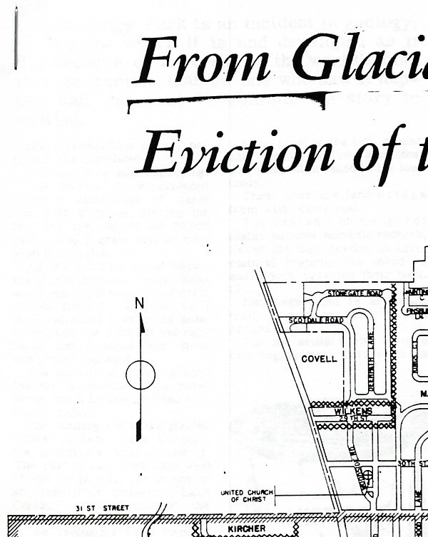
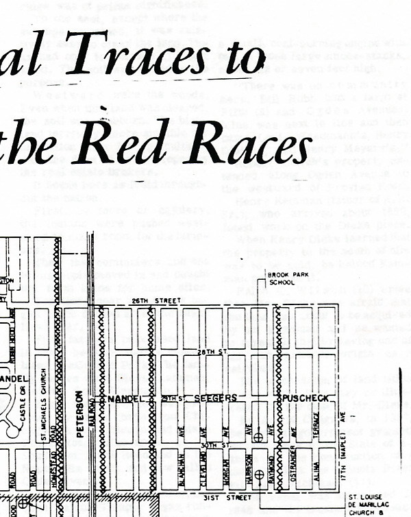
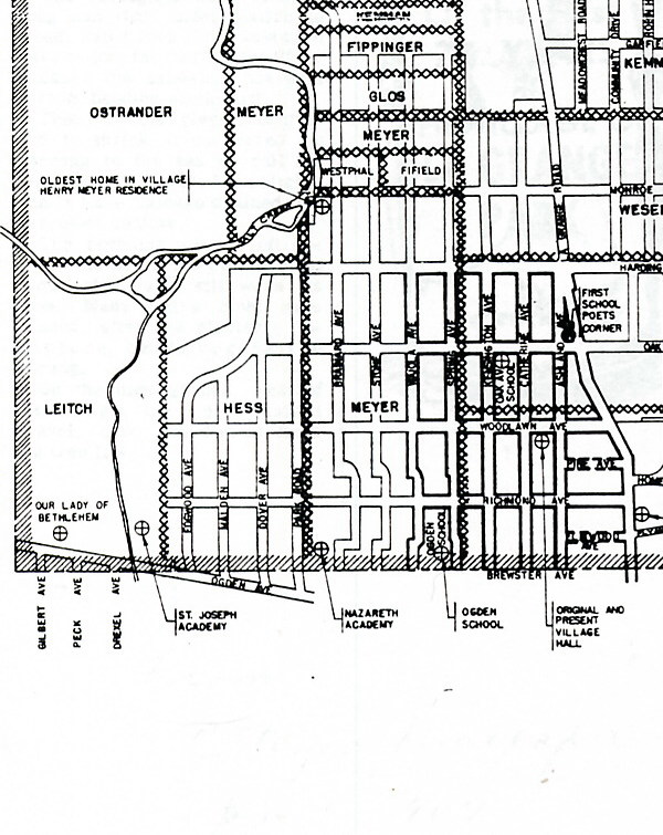
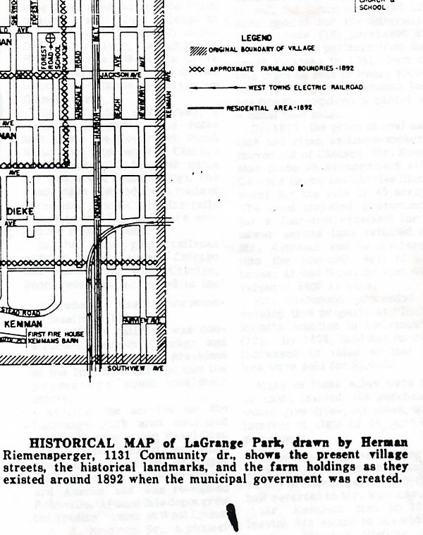
An Early Map of La Grange Park
For further details click on the quarter of the map you want enlarge. Be warned, I will take some time for the enlargement to be displayed.
For further details click on the quarter of the map you want enlarge. Be warned, I will take some time for the enlargement to be displayed.
The historical map of LaGrange Park, drawn by Herman Riemennperger, 1131 Community Drive, shows the village streets, historical landmarks and the farm holdings existed around 1892 when the village government was created.
Last Modified: 01/04/2007