www.FranzosenbuschHeritageProject.org
Home
Village of Broadview
(Broadview Golden Jubilee -- 1914 to 1964, Articles by Val Koch,
published by the Village of Broadview)
"Bustling Broadview was once site of Native American
hunting grounds"
In the early history of Cook County, Illinois, there rested in
the tableland of the Des Plaines River, a reservation known as Proviso Township,
bounded on north by Leyden, east by Cicero and Riverdale, south by Riverside and
Lyons, and on the west by DuPage County. Up to the year 1870 this particular
territory contained 36 sections, of which Broadview eventually became known as
sections 15, 21, and 22.
The Des Plaines River flowed through the center of the east
third of Proviso Township. The entire area consisted chiefly of majestic elm trees,
many of which were five feet in diameter, surrounding a small lake which offered
a haven for ducks and other migratory birds.
Broadview lay near the edge of this lake, which teamed with
fish. Through the center of Proviso Township, winding toward Lemont, Illinois,
was a strip of forest land, which provided hunting grounds for Native Americans
of the Pottowatomie, Chippewa and Ottawa tribes; and skirmishes were reported
between the Native Americans and earliest settlers in this area.
As late as 1900, a small settlement of Pottowatomies lived at
17th Avenue and the Illinois Central tracks. Many
Native American arrowheads and other
relics were found along the banks of Salt Creek.
Near the area of 17th Avenue
and Roosevelt Road, rose a hill, aptly named Wolf Hill, because of several wolf
lairs in and around it. Later this hill was leveled for road construction.
This section of land, then, which was partly swamp, was
destined to become the Village of Broadview. Eventually, the lake and muddy
areas were partially drained by means of surface drainage in the Des Plaines
River, and crops were then raised on this land. Potatoes and corn were the
first crops, as well as oats, wheat, and timothy. Later, the land was cultivated
as truck gardens for various markets in the immediate area. As time went on, a
more modern drainage system, tile, was installed, which eventually completely
drained the entire reservation.
| The first white settler in Proviso Township was Aaron Parsell,
who resided on Section 29 in the year, 1832. Today, this section is known as
Westchester. For the purpose of title and geographical identification, Broadview
is located on a tract of land known as Sections 15, 21, and 22, township 39
north range 12, east of the third principal meridian.
Historical records show a sale of land consisting of 80 acres in the
Broadview area, was purchased from the United States government for $120.00.
This was on June 25, 1835, and the purchaser was one, Frederick Bronson. On
August 8, 1835, he purchased 160 acres of land at public sale for $200.00.
By 1870 all the land of the future Broadview was owned by more than 35
different people. See the map of Broadview
Landowners as they were in 1870. |
|
"In 1843 township 39, range 12 was officially surveyed.
This is Proviso Township and was the last township surveyed in Cook
County. The first U. S. government survey in Cook County area was
made in 1821."1
"This area was organized into a town under the name of
Taylor Township, but later in the month of April 1850 the name of Proviso
was substituted for Taylor. Proviso was suggested by the prominence
still maintained in the minds of the people by the Wilmot Proviso."2
1 A. T. Andreas,
History of Cook Country Illinois, Chicago, 1884, page 360
2 Ibid, page 800
|
In the 1880s the railroad came through the area and the first
subdivision was platted. Eighty acres of northeast Broadview was named the
Western Addition, presumably of Maywood, in 1883. In the same year, the
Chicago, Madison and Northern Railroad Company (which became the Illinois
Central Railroad) bought a right of way from farmers a half a mile south of this
subdivision. In 1890, the Union Land Association was formed by 35
investors and $100,000 in capital. The following year they subdivided a
portion south of 12th
Street and drew in street numbers from Ninth Avenue to 21st
Avenue. They named their map Broad View (two words). On an 1899 Rand
McNally map of Chicago, the railroad station at 17th
Avenue and the railroad right of way was shown as Broadview (one word).
In 1893, the year of the Colombian Exposition, a real estate
firm by the name of Foreman and Cummins began to clear the land and to subdivide
it. Each lot was to have a frontage of 300 feet, and there were to be four lots
to one block. Foreman and Cummins pitched a large tent near 11th
and Roosevelt Road, advertised "Free Refreshments" on a sign on top of the tent,
and went into the business of selling lots. Very little resulted from the subdivision, however, and except
for a few scattered houses, most of the area remained farmland. Almost all of
the early settlers in Broadview were of German origin.
At the turn of the century, a farmer named Muir built his
farmhouse on Ninth Avenue and 14th Street. His
farm later burned to the ground. In 1870 Ernest Hoermann had built his farmhouse on
the southwest corner of 17th Avenue and 14th
Street. Seventeenth Street was named after him in those days, and his house
still stands today. This, then was Broadview at the turn of the century; a few
scattered farmhouses and a small settlement of homes, about twenty in all, in "80
Acres". "80 Acres", or Oklahoma, as it was commonly called, was that territory
lying between what is now Eisenhower Expressway and Roosevelt Road, and
extending from 13th Avenue west to 17th
Avenue.
The territory was unincorporated, and there were no building
restrictions; in fact, there weren't many building restrictions anywhere. "80
Acres" endured and thrived for a number of years. It contained a one-room school
house, located in almost the identical spot where Roosevelt School now stands.
Meetings were held in this schoolhouse before a village hall
was built, and many good times were held in it, too. It was regrettable, that
owing to the difficulty in getting teachers to come out to "80 Acres", the
schoolhouse was closed down, and the students transferred to the No. 5 School,
now known as Garfield School, at Ninth Avenue and Van Buren Street in Maywood.
The children who lived south of Roosevelt Road trudged to school at Cermak Road
and 25th Avenue.
Two gentlemen from Maywood then opened a Sunday School in the
old schoolhouse. Mr. B. B. Coons and Mr. Davis spearheaded the opening of the
Sunday School.
A bunch of classmates meet at the Hoermann farmhouse each
morning and walked to Cermak Road down 17th
Avenue, and then right to 25th
Avenue. In bad weather, there was mud,' rain pools, slush, and snow.
In extremely had weather, the school closed down.
There were no age requirements when a child started first
grade in those days. If a youngster was under five and wanted to start school,
and his/parents consented, he was right there with the rest of them. Aside from
a schoolhouse and a saloon in "80 Acres", there wasn't much of anything else
in the way of stores. The residents and farmers hitched up their horses
and buggies and went to Forest Park, or to Maywood, to do their shopping. This always turned out to be a half day event, where one met
old friends and chatted over buggy wheels.
"80 Acres" boasted modern
sidewalks, which were planks laid out on two by fours, and wide enough for two
people to use. They didn't last too long, however. The weather rotted the
lumber. Those walks which didn't fall apart, were eventually torn up.
There were no street lamps installed in Broadview. Roosevelt
Road was a single lane graveled roadway, and veering north from it, was a single
lane dirt road. The graveled road was used for funerals on their way to Oak
Ridge, or Mount Carmel, which were the only cemeteries west of Broadview at that
time.
The dirt road was popular with teamsters hauling crushed stone
from the Hillside quarry, and by farmers. Traffic was light compared with today,
and there were none of the problems as we know them now.
In the summertime, Sunday afternoons were very popular, due to
"80 Acres" fine baseball team, which was organized in 1912. The song on
everybody's tongue at that time was "Harrigan, That's Me", and so the "80 Acres"
team was called the "Harrigan Colts", and a fine looking body of young men they
were, all decked out in their green and white uniforms. And could they play ball? Hardly ever did a team come out that
could beat them, and the best sandlot teams that Chicago had to offer were taken
on. The star pitcher was George Cote, who was Broadview's first treasurer.
In 1914, there was talk of incorporating the territory of
Broadview. Maywood offered to enfold Broadview into her boundaries, but many
people were against such a move.
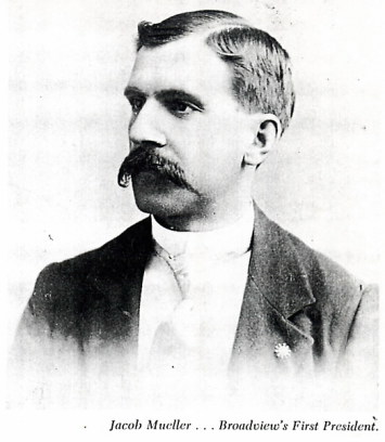
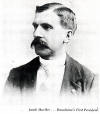 An election was held under the guidance of Jacob Mueller, who
became Broadview's first president, John Reindecker, and J. Radtke, to see what
the people would choose. They voted for incorporation, and it was on January 22,
1914, under the laws of the state of Illinois, that Broadview became a village.
Some of the village incorporation papers can be viewed at
Broadview Incorporation Papers.
An election was held under the guidance of Jacob Mueller, who
became Broadview's first president, John Reindecker, and J. Radtke, to see what
the people would choose. They voted for incorporation, and it was on January 22,
1914, under the laws of the state of Illinois, that Broadview became a village.
Some of the village incorporation papers can be viewed at
Broadview Incorporation Papers.
Photo from Broadview Golden
Jubilee -- 1914 to 1964
At this time, the
boundaries were pretty much the same as they are today, with one important
exception. The boundary on the east extended to 800 feet past First Avenue,
bounded on the north by Roosevelt Road and on the south by Cermak Road.
(See the maps at Broadview Boundaries).
| One always knew who won an election, in those days, without
help of radio or television. You glanced over toward village hall on election
day. The campaigners whose horses were tied up to the hitching post towards
evening were the winners. Those whose horses and buggies left early in the
afternoon, were the losers. While talk was going on in Broadview regarding incorporation,
there was talk of similar nature going on in a suite of rooms located in the
Marquette Building in Chicago. A group of men were interested in organizing a
racetrack in the Chicagoland area, and after scouting about for a suitable
location, they decided on a piece of land that was within the boundaries of
Broadview.
|
|
How Did Broadview Get It's Name
"At the time
the Village of Broadview was to be incorporated, my grandfather, Jacob
Mueller ... asked his family to choose a name for the village.
"My
mother, Elizabeth (Mueller) Coté
suggested they adapt the name of BROADVIEW after the name of the Illinois
Central Railroad depot, because in those days maps carried the names of
only large cities and all railroad depots. Therefore, it would put
'BROADVIEW' on the map."
- James G. Coté Sr. (from
Broadview's Golden Jubilee book)
|
The site they chose consisted of 320 acres of level land,
bounded on the north by Roosevelt Road, on the south by Cermak Road, and the
east and west boundaries were First Avenue to Ninth Avenue. On May 27, 1914, the
Speedway Park Association was incorporated under the laws of the State of
Illinois.
During the life of this association, it was involved in
several minor law suits, covering mechanics, liens, etc., but the project was
eventually cleared.
Back on February 12, 1914, the Speedway Park Association announced
that they had placed a contract for the construction of a two mile board track,
to be completed by June 1, 1915, under terms of the agreement. This created jobs
for everyone wishing to work, and so the new village of Broadview started off
with a very prosperous beginning.
| It has been estimated that the construction requirements
employed 500 men. Actual construction work started on April 19, 1915. The land
was vacant, so there was no time lost in wrecking. The track surface was
constructed with two by fours laid edgewise, spaced with a quarter inch gap
between them, and running in the direction of planned traffic flow. |
|
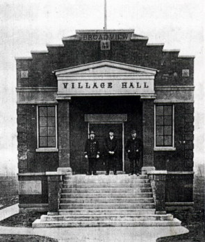
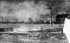
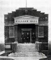 This
picture of the Village Hall was one of the first taken after the hall was built.
On the steps are Village Marshall H. Radtke and Village Trustee Fred
Schultz. The third man was a neighbor from
Maywood. This
picture of the Village Hall was one of the first taken after the hall was built.
On the steps are Village Marshall H. Radtke and Village Trustee Fred
Schultz. The third man was a neighbor from
Maywood.
Photo from Broadview Golden
Jubilee -- 1914 to 1964
|
The supports were made of wood set in proper intervals, upon
concrete foundations or piers. The track was 60 feet wide on the homestretch,
and 70 feet wide on the turns, and the back stretch was 50 feet wide. It was
also planned to have a golf course, polo field, and an aviation field. All plans
were located in the original contract.
The financing was secured by means of a membership
proposition. The full allotment of 1,000 members at $250 a member was secured,
which placed $250,000 into the initial treasury. In addition to this, the
directors pledged $500,000 for which they would take stock, if necessary. It was
further contemplated on selling another 10,000 memberships at $50 a year, which
would not carry any stock.
The contract for the track called for a minimum expenditure of
$500,000 and the maximum of $1,000,000. The contractor gave a bond of $200,000
to complete all of the original plans by June 1, 1915.
The first derby on the speedway racetrack was on June 26,
1915. Twenty one cars began the race at 10:30. Exactly five hours, seven
minutes, and 26 seconds later, Doric Resta, driving a French Peugeot, flashed
across the finish line, a winner and holder of a new world record.
Resta had averaged 97.58 miles per hour, for a total of 500
miles. He beat by more than 50 per cent, the fastest time ever made by a
railroad train. On August 7, 1915, a match race between four of the best drivers
in the world was run. Dorio Resta, winner of the derby, romped home a victor
over Earl Cooper, Barney Oldfield, and Bat Bunnan, the American favorites.
It is worthy to note that America's first auto race was won in
a field of ten in Chicago on Thanksgiving Day, 1895, at a speed of less than ten
miles per hour.
On July 28, 1918, Ralph DePalma won the International
sweepstakes at Speedway.
The crowd was estimated at 15,000 in the grandstands,
bleachers and paddock. DePalma was awarded $17,000 for first place, and the
second place winner was a Frenchman by the name of Louis Chevrolet.
The Park grandstand and open field scats suitable for aviation
meets, had a capacity of 200,000. The racetrack, apparently, was not a financial
success.
When a committee from the Surgeon General's office of the Army
was ordered to Chicago for the purpose of making a preliminary survey and to
recommend a site for hospital use, they considered two locations:
- the
Field Museum area
- the Speedway Racetrack.
The final decision went to Speedway and actual hospital
construction began in 1918.
At that time, the Public Health Service was responsible for
hospitalizing wounded and disabled troops during World War I. Accordingly, a
contract to purchase the site for the hospital records was entered into between
Edward Hines Sr. and the Public Health Service.
The hospital was dedicated by Marshal Foch of France, on
November 6, 1921, and on August 8, 1921, the first patients were admitted. It's
first, official name was the United States Public Health Service Hospital.
In the beginning, people kept referring to it as the Speedway
Hospital. Even after an executive order on October 24, 1921, by the president of
the United States, designating the hospital as the
Edward Hines Jr. Hospital,
the newspapers and the public in general continued to refer to the Speedway
Hospital for many years, until eventually the incorrect name was lost to time.
It is interesting to note that in 1928, Colonel Scott,
hospital manager, contracted for erection of the metal fence around the entire
reservation. This fence still stands today.
Legend has it that the fence was erected to accomplish a
two-fold purpose; namely to keep the fowl hunters from Broadview and other towns
off the hospital grounds and also to keep patients on the grounds. It seems there was a tendency on the part of some of the
patients to walk over into Broadview to frequent a saloon that was located on
9th Avenue, just south of the main hospital building.
Although Hines Hospital was no longer within Broadview limits
in 1920, here is a sideline of events at that time which may be of interest. In
1920, after remaining in Grant Park, Chicago, for two years, the airmail
terminal of the post office department was moved to
Checkerboard Field at the
south edge of Maywood.
The reason for this move was because of the increased
congested conditions at the lake front in Chicago. David D. Behncke and Bert R.
J. Russell had opened this field in 1919, and used it as a shipping center.
In 1923, Behncke sold the field to
Wilfred Alonzo Yackey, a
former military and airmail pilot. From 1923 until Yackey's death in an airplane
crash, the Yackey Aircraft Company and Checkerboard Field were the center of
aircraft manufacturing activities in the Chicago area.
During the early 20's Checkerboard Field was moved across
First Avenue to the grounds of Edward Hines Jr. Memorial Hospital, where it
remained until the post office turned over transcontinental routes to private
contractors in 1927.
In those days, no night flying was allowed, until in 1924,
when night flying was adopted. No one worked on Sunday, the one day that planes
were grounded.
On April 15, 1926, a slender Kelly Field graduate who worked
his way up to a captain in the Army Air Corps Reserve, made the first airmail
flight from Chicago (the Government air field on the hospital grounds) to St.
Louis. The plane used for this inaugural mail run was a DeHaviland. The pilot
was Captain Charles A. Lindberg.
The urge to expand, to build, to improve, struck Broadview in
the roaring Twenties as elsewhere, and a great program of street paving, water
and sewer installations, sidewalks and street lights, was put into effect.
In 1927 the LaGrange Citizen wrote about Broadview's
commitment to growth in several articles, one of which can be read at
 Broadview Begins 500000 Dollar Program_LaGrange Citizen_Apr 7 1927.
Some construction of houses was actually started, and along 18th
Avenue and 19th Avenue north of Roosevelt, a
number of fine homes were built, giving the name of "Gold Coast" to this
section. Major improvements were planned for Roosevelt, expanding it to
forty feet in wide. See
March
1928--Improvements to Roosevelt Road.
It was on May 29, 1917 that the Chicago Tribune ran a story
about corruption -- and Broadview was picked as the example in its story --
Chicago Tribune May 29 1917_BROADVIEW COPS AND JUDGES WAX FAT ON AUTOISTS.
It was a sign of the times and a situation which was repeated in similar ways
across the country...as well as a few years later by another Broadview Police
Chief, Marshall Huszar. See article
Term For Huszar Cheers Motor Club_LaGrange Citizen_April 21 1927 and
Early Residents and Settlers.
Broadview's business district is remembered in a June 1979
interview of Victor Gaddis in
Broadview Business
District 1920s.
In 1930, the Depression hit Broadview and things slipped to a
standstill again. For example, an enterprising real estate office brought
'prospective customers' out to Broadview on the Illinois Central train, wined and
dined them, and then offered to give each client a free lot with the purchase of
one lot.
Early in 1930 a section of Broadview was "disconnected" from
the Village and made part of the Cook Country Forest Preserve District.
This area was a strip of land between Roosevelt and Cermak (22nd
Street) Roads to the east of First Avenue to a distance of 1320 feet.
The Hines Hospital/Vaughn Central Hospital complex was also removed from the
Village of Broadview making its east boundary Ninth Avenue.
During May of 1930, in the aftermath of village elections
there was some excitement when
Marshall
Andrew Borg and others assaulted one of the new
(but not yet sworn in) village officials. Read about these event from the
pages of Chicago newspapers. See
May
1930--Exciting Times.
Graft and corruption was an evil sign of the times and Broadview did not escape
its influence. The county treasurer, responsible for collecting and
passing on some of the taxes to Broadview, was accused (and later indicted) for
skimming off monies. See
Jan 1933--More Exciting Times. Also in February of 1930 James Grant,
village clerk of Broadview died in a fire. (See
Concede Broadview Clerk Fire Victim, LaGrange Citizen, Feb 27 1930.)
Perhaps the most significant long-term event of 1937 was the
election of Merritt Braga to his first term as village president; a position
from which he would lead Broadview through many challenges. He grew to
become the "dean of mayors", serving for 42 continuous year until his death in
1980. (Read newspaper stories about Merritt
Braga.)
Things remained pretty much this way until 1940 and 1941
before the second World War started. With the defense boom Broadview again came
to life.
Many tax delinquent lots were cleared of indebtedness, and
home building was once more under way. The first building took place in that
section east of 17th Avenue and south of
Roosevelt Road, which became known as the "Hollywood Section".
The west portion of the Cold Coast also came in for some
intensive construction, so by the time of the attack on Pearl Harbor, the population had
increased considerably.
A few stores began to locate here, to service the ever
expanding population.
About 1942, there was considerable activity in the section
west of 17th Avenue and south of Roosevelt
Road, and this became known as the "Garden Section". "80 Acres" also came in for
some face lifting, and a number of very attractive homes were built in that
section.
In 1942, a zoning ordinance for the entire village was
adopted, and since that time, all building has been done to conform to the
ordinance, as well as the ordinance regulating the types of buildings that can
be erected.
There have been a number of changes in the zoning ordinance,
hut these were made only after a full hearing by the zoning board of appeals and
the enactment of a new ordinance by the village board.
In 1940, a park district was formed, encompassing the entire
area of Broadview. The members of the Park Board have done wonders with
playgrounds for the youngsters, and recreational activities for all ages.
In the same year, a business district along Harrison Street
was abolished, and the stores moved to other locations (some on Roosevelt Road)
when the Congress superhighway (now Eisenhower Expressway) came along. An
ornamental street lighting system was installed through the business section
along Roosevelt Road.
The new village hall was formally opened to the public on
March 18, 1954. It had been built over and around the first wooden village hall,
which had been erected in 1915. At the time of the dedication in 1954, Merritt
Braga was president of Broadview, as he has been since 1937.
The completion of the Congress Expressway (now the Eisenhower)
in the mid-1950s had a significant impact, eliminating some homes and street
while increasing other development in the village. The business district
on Roosevelt Road began to flourish. What had been a few little shops
became a shopping district comprised of supermarkets, gas stations, butchers,
show stores, pharmacies, a dairy store, restaurants and a greenhouse. The
change made life in Broadview more convenient.
As of 1964, Broadview had grown into a community of about
3,000 families, 141 commercial units consisting of various shops, supermarkets,
etc., and about 80 industrial plants.
In 1967 the fire department moved into its new firehouse
facility on 25th Avenue and 14th
Street.
On September 22, 1991, the newly constructed Municipal and
Police Department building at 2350 South 25th
Avenue was dedicated. It replaced the building on Roosevelt Road and 16th
Avenue.
Faces and Places of the Bygone Days
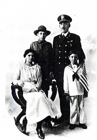
Police Chief Huzar
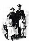 Joe
"Indian Joe" Huzar with his wife Elizabeth, their sons George and Clarence (in
the sailor suit).
Joe
"Indian Joe" Huzar with his wife Elizabeth, their sons George and Clarence (in
the sailor suit).
Joe Huzar served as the first Chief of Police of Broadview.
Each night he phoned home after midnight to let Elizabeth know where he was.
If a call didn't come in he was immediately traced in case of accidents which
did happen. It was very easy for him to catch speeders. His
motorcycle and car were factory built to for speed.
Photo from Broadview
Golden Jubilee -- 1914 to 1964
Mrs. Huzar was a shrewd businesswoman and a good church
worker.
They had a daughter, Ruth, who passed away at age six.
 Streets
and Byways
Streets
and Byways
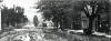
17th Avenue and Roosevelt
Road pictured about 1890, looking south.
Photo from Broadview
Golden Jubilee -- 1914 to 1964
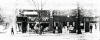 Broadview's
first drug store was located at the southwest corner of 16th
and Harrison in 1925. It was owned and operated by Tom Musser.
Broadview's
first drug store was located at the southwest corner of 16th
and Harrison in 1925. It was owned and operated by Tom Musser.
Photo from Broadview Golden
Jubilee -- 1914 to 1964
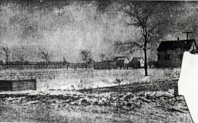
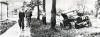 The
streets of early Broadview we could be difficult to travel. Some of the
streets were lost with the construction of the Eisenhower Expressway. In
1925 this "stuck" auto was photographed at 17th
Avenue and Harrison Street.
Photo from Broadview Golden Jubilee -- 1914 to 1964
The
streets of early Broadview we could be difficult to travel. Some of the
streets were lost with the construction of the Eisenhower Expressway. In
1925 this "stuck" auto was photographed at 17th
Avenue and Harrison Street.
Photo from Broadview Golden Jubilee -- 1914 to 1964
 Photo
from Broadview Golden Jubilee -- 1914 to 1964
Photo
from Broadview Golden Jubilee -- 1914 to 1964
Another view of Harrison Street, this one at the
corner of 14th Avenue. This, too, was lost to the "Ike".
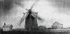
In 1884 this windmill (pictured to the left) was
located on the John Jung farm, Puscheck Road (since renamed to Gardner Road).
This site is now occupied by Photopress, Inc. People came from miles
around to have their grain ground. Mr. Jung served in the Civil War and
was the grandfather of Mrs. Hulda Knox of Broadview.
Photo from Broadview Golden Jubilee --
1914 to 1964
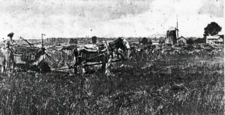
 Fred
Jung operating a Deering Binder.
Fred
Jung operating a Deering Binder.
Photo from Broadview
Golden Jubilee -- 1914 to 1964
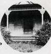
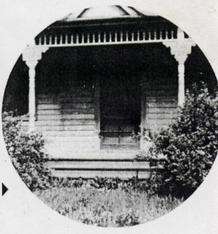
This was the farm house of Fred Schultz in 1905.
It was located on 17th Avenue south of
Roosevelt Road.
Photo from Broadview Golden
Jubilee -- 1914 to 1964
For more on Broadview, see:
For more information on the early days of the
area please check:
Also available is the
Broadview
Zoning Map 2000.
Sources were used in the compilation of this entry include but
are not limited to:
- Broadview Golden Jubilee -- 1914 to 1964, Articles by Val Koch,
published by the Village of Broadview
- Records and materials supplied from the archives of Broadview Historical
Society--courtesy of Michael Kaminski
- A. T. Andreas, History of Cook Country Illinois, Chicago, 1884
- "Cobbs Directory - Pre 1900 Maps Springfield Historical Society", Proviso
Township Library", 1898
Last Modified: 02/17/2007
 An election was held under the guidance of Jacob Mueller, who
became Broadview's first president, John Reindecker, and J. Radtke, to see what
the people would choose. They voted for incorporation, and it was on January 22,
1914, under the laws of the state of Illinois, that Broadview became a village.
Some of the village incorporation papers can be viewed at
Broadview Incorporation Papers.
An election was held under the guidance of Jacob Mueller, who
became Broadview's first president, John Reindecker, and J. Radtke, to see what
the people would choose. They voted for incorporation, and it was on January 22,
1914, under the laws of the state of Illinois, that Broadview became a village.
Some of the village incorporation papers can be viewed at
Broadview Incorporation Papers.